UPDATE. As of July 5, the fire was 60% contained and evacuation orders were lifted.
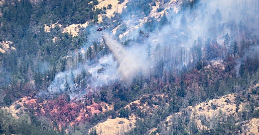
CALISTOGA, Calif. — The Toll Fire in Napa County, which started on July 2, 2024, northeast of Calistoga, has burned 50 acres and is currently managed by the CAL FIRE Sonoma-Lake-Napa Unit. The fire, driven by wind and burning side-slope to the southwest, has led to evacuation orders for Zones NPA-E113 (north, south, and east of Lake County Hwy and west of Palisades Rd) and NPA-E103 (north of Old Lawley Toll, south of Hwy 29/Oat Hill Rd, and east of Lake County Hwy), and warnings for Zones NPA-E104 (north, south, and east of Livermore Rd and west of Oat Hill Rd) and NPA-E105 (north of Lake County Hwy, south of Livermore Rd, east of Lake County Hwy, and west of Oat Hill Rd).
Approximately 114 residents are affected. Significant resources have been deployed, including 300 personnel, 3 helicopters, 20 engines, 2 dozers, 7 water tenders, and 4 crews. Numerous firefighting air tankers are conducting suppression missions as conditions allow. Road closures include Old Lawley Toll Road. Calistoga is not under evacuation at this time. Stay updated via CAL FIRE's webpage and evacuation maps.
Fire Details
Size: 50 Acres
Location: Old Lawley Toll Road, northeast of Calistoga
Start Date: 07/02/2024, 9:42 AM
Coordinates: Latitude 38.6360964652854, Longitude -122.583753713245
Cause: Under Investigation
Management: CAL FIRE Sonoma-Lake-Napa Unit
Personnel Involved: 300
Resources Assigned:
3 Helicopters
20 Engines
2 Dozers
7 Water Tenders
4 Crews
Current Situation
Command: Unified with the Napa County Sheriff's Office
Behavior: The fire is wind-driven, burning side-slope to the southwest, still east of Silverado Trail.
Augmentation: Significant increase in resources to combat the fire.
Evacuation Impact: Approximately 114 people affected by evacuation orders and warnings.
Evacuation Orders
Zone NPA-E113: North, South, and East of Lake County Hwy and West of Palisades Rd.
Zone NPA-E103: North of Old Lawley Toll, South of Hwy 29/Oat Hill Rd, and East of Lake County Hwy.
Evacuation Warnings
Zone NPA-E104: North, South, and East of Livermore Rd and West of Oat Hill Rd.
Zone NPA-E105: North of Lake County Hwy, South of Livermore Rd, East of Lake County Hwy, and West of Oat Hill Rd.
Road Closures
Old Lawley Toll Road
Additional Information
Numerous firefighting air tankers are conducting suppression missions as conditions allow.
A potential impact zone affecting 114 residents has been identified based on current evacuation orders and warnings.
Resources
Camera Feed: St. Helena South Napa
Evacuation Map: Genasys Evacuation Map
Social Media Updates
For more detailed information and continuous updates, please refer to the CAL FIRE website and the linked evacuation maps. Stay safe and follow all evacuation orders and warnings.


Right on with the fire story. Thank you.
Thank you for this timely information. Clear, concise, helpful coverage of a high-risk event. .