NAPA VALLEY, Calif. — On a recent sunny Sunday afternoon many people were walking with their families and dogs on the Napa Valley Vine Trail in Calistoga. That portion of the trail is officially closed, but by early summer, after its grand opening, the NVVT will connect Calistoga to St. Helena.

The Napa Valley Vine Trail is a huge independent grassroots public-private partnership and project fueled by donations, dedication and determination that will provide a Class 1 trail, separated from traffic, for 47 miles between the Calistoga Depot and the ferry terminal in Vallejo. By late summer, the 5.5-mile portion of the trail from the Vallejo ferry building in Solano County to Mini Drive in American Canyon will be open. At that point, 32.5 miles of NVVT will be completed, leaving only 14.5 miles to be built.
“We’re excited about both the north and south sections being done,” said Shawn Casey-White, NVVT executive director. “That will truly be the exciting opportunity to connect Solano County and Napa County and hopefully create a transportation corridor that connects both our communities.”
Casey-White has been the executive director with the NVVT for the past two years. Chuck McMinn, NVVT founder, leads the Napa Valley Vine Trail Coalition’s board of directors. Under his leadership the nonprofit has gathered 32 groups and organizations into the coalition.
“We just did a five-year strategic plan, and we put it down on paper that all 47 miles will be done by July 1, 2028,” Casey-White said. “We are optimistic, and we’re working feverishly toward that goal.”
The year 2028 will be the coalition’s 20th anniversary.

In December, Kit Crawford and Gary Erickson, owners of the Clif Family Winery in St. Helena and the Clif Family Foundation, pledged a $2.5 million challenge matching grant to help raise the funds needed to build the segment between Yountville and St. Helena. They are asking vineyard owners to pay $50 per acre of producing vines for five years. To build the 12.2-mile segment, mostly adjacent to the Napa Valley Wine Train tracks, will cost an estimated $30 million. That effort is expected to raise $5 million with $1.5 million already pledged. Both Napa County and the coalition have pledged $5 million each, and the City of St. Helena has pledged $900,000. The coalition will seek a $15 million state grant to pay for the rest.
Ten town hall meetings are set to unveil plans for the St. Helena-to-Yountville trail. They will be held later this month and early February for the first phase and in April for the second phase. Four of the meetings will be on Zoom; six will be live at the Carnegie Building in St. Helena, the Rutherford Grange and the Yountville Community Center. The first meeting will be at 4 p.m., Tuesday, Jan. 30, at the Carnegie Building in St. Helena. The full schedule is here.

Waiting for spring
Currently, construction crews on the trail between Calistoga and St. Helena are waiting for spring, when the weather is drier. In the areas where the NVVT is adjacent to vineyards, crews will install Park Tread material, which is made from quarried shale/chert and is designed for durability. Casey-White said it will be more than 12 inches deep and allow tractors and other vineyard equipment to go over it without damaging it. The material, though, cannot be installed during wet weather. Crews instead are working on all the other projects, including paver treatments in St. Helena just north of Pratt Avenue and split-rail fencing just north of Larkmead Lane.
Riders and walkers will cross Highway 29 near Larkmead Lane, enter into Bothe Napa Valley State Park and cross again on Big Tree Lane, near CalFire headquarters. Just opening up Bothe to the community and having them experience the beauty of the state parks is a nice additional feature of the vine trail, Casey-White said.
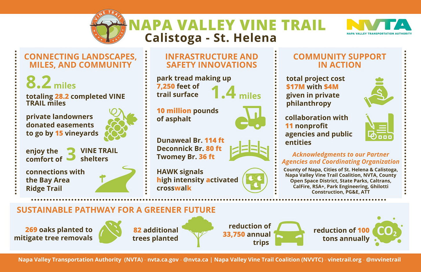
Users of the trail will cross Highway 29 with the aid of the HAWK (High-Intensity Activated CrossWalk) signal that stops traffic from both the north and south. Casey-White said McMinn and Jean Charles Boisset recorded a safety video with the California Highway Patrol that demonstrates how to activate the HAWK system, which is between Solage and Four Seasons on Silverado Trail near Calistoga.

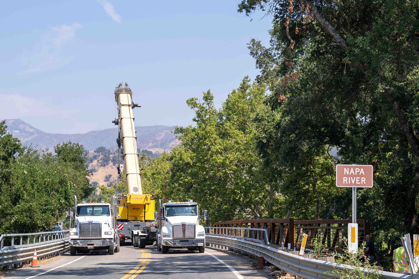
One of the more interesting parts of the trail construction happened when Ghilotti Construction Co. laid the 114-foot-long steel bridge over the Napa River on Dunaweal Lane.
“It was amazing to see Ghilotti drop this bridge within inches on their posts and do it perfectly,” Casey-White said.
It is one of three steel bridges in the area; the other two are in the Twomey Vineyards and in a vineyard near the Bale Grist Mill.
Discovering the Vine Trail
The Yountville-to-Napa section of the trail that was completed in 2016 is busy, especially on the weekends. This reporter has ridden his bicycle hundreds of miles on Silverado Trail and Highway 29, and there’s nothing better than a paved trail that is separated from traffic. It’s obviously safer than riding on the side of the road and allows a rider or walker to enjoy the world-class views that make up the Napa Valley. Incidentally, we often take those views of the Palisades and Mount St. Helena for granted.
During the COVID-19 pandemic – it first appeared in January 2020 in the United States – Casey-White said people “discovered” the Napa Valley Vine Trail.
“When you couldn’t go to a gym to work out or your typical places, you had to find the outdoors,” she said. “And many people found the Vine Trail, so our numbers of actual users went up. By 2021, we had doubled the use, over 500,000 users.”
The numbers of users are measured in three sections of the trail, with Eco-Counters, inductive loops under the asphalt, counting both pedestrians and cyclists, either northbound or southbound.
“We’ve been seeing those consistent numbers at about 500,000 year over year,” Casey-White said.
Even though she doesn’t have December numbers, the Napa Valley Vine Trail website totals 396,873 users in 2023 and 2,896,686 total users since the counting began.

Of the 500,000 annual users, Casey-White said 70 percent of users were local and the rest were tourists.
“I think people think the trail is there for tourists and a fun weekend,” she said, “but actually, if you’re out on the trail on a Sunday, you’re more likely to see a family walking, someone riding up to the golf course in Yountville or down into Kennedy Park. So it’s good to see that. And we hope that these sections in Calistoga will open more opportunities for folks that live in the north part of the valley.”
To determine if someone was a local or tourist, people stood near where the counters were and asked each user their ZIP code. That was done a couple of times, but not last year.
“It’s a little informal, but we try to be consistent with our intercept surveys to see if we’re getting the right numbers,” Casey-White added.
Then she added one more thing: “I don’t want to leave out the City of Napa. We are really excited about working with the City of Napa because one of the biggest feedbacks that we get is people can’t find the trail or the Soscol junction confuses people or they can’t get down to the loop by the Napa River. So we have been working with the city’s Public Works Department and they’re going to be installing thermoplastic wayfinding share-the-trail signs on the trail throughout downtown Napa.”
The signs will be all the way from Solano and Redwood avenues down to Kennedy Park.
“Those should help, and then we’re also refreshing the arrows and the welcome trail signs throughout the downtown,” she said. “We’re hoping that it will be more inviting, it will be more visible, and even the traffic that’s on the highway will be able to see those signs and navigate that. So whether you’re up on First Street or crossing the bridge, you’ll be able to see those signs and catch the trail wherever you are.”
For more information on the Napa Valley Vine Trail, visit here.
Dave Stoneberg is an editor and journalist who has worked for newspapers in both Lake and Napa counties.


Great coverage Dave! This NVVT story encourages biking/walking in our beautiful stretch of Valley. Thanks!